Florida Fires - June 1998
|
|
National Aeronautics andSpace Administration Goddard Space Flight Center |

Abnormally dry conditions combined with record high temperatures dried out woodland areas across the state, making conditions particularly ripe for wildfires. Fires visited 39 of Florida's 67 counties between May 25 and June 25 and burned more than 100,000 acres of land. Thick blankets of gray smoke were associated with burning eyes, scratchy throats, stuffed noses and heavy wheezing. Many communities were evacuated and major highways closed as firefighters battled to save forests, homes, and property.
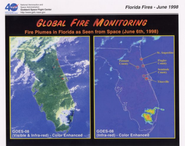
The
images on the front are National Oceanic and Atmospheric Administration (NOAA)
Geostationary Operational Environmental Satellite (GOES)-8 false-color
images of the Florida peninsula on June 6, 1998.
The image at left is a combination of visible and infrared (heat) data showing smoke plumes and hot spots (red areas) along Florida's east coast. Some of the smoke plumes actually spawned cumulus clouds as water vapor condensed on aerosol particles (called cloud condensation nuclei) in the smoke. This is evident off the coast of Cape Canaveral as westerly winds carried the smoke out over the Atlantic Ocean.
The image at right is a color-enhanced infrared image of the "hot spots." Infrared images from satellites allow scientists to see a snapshot of the amount of radiation being emitted from the surfaces of objects such as clouds, land, and the ocean. In this image, land surface areas emitting high amounts of infrared radiation because of the fires have been colored red and are easily detectable on the image. These images prove to be extremely valuable as smoke typically hampers efforts to correctly map wildfires from aircraft. The accuracy of these images aids firefighters in tracking and forecasting the movement of wildfires.
GOES-8 was launched into a geosynchronous orbit, which means it orbits the equator at a speed matching the Earth's rotation, allowing it to hover continuously over one position on the surface, at an altitude of 35,800 km.
Additional information can be found on the World Wide Web at:
Global Fire Monitoring
http://modarch.gsfc.nasa.gov/fire_atlas
Related NASA Websites
NASA's Earth Science Enterprise
NASA's EOS Project Science Office
Images
courtesy of NASA's EOS Terra (AM-1) Visualization Team and GOES Project Science
Offices.
For the Classroom: Research Topic
As wildfires become more common and destructive, "prescribed burning" is often mentioned as a wildfire prevention tool. Have your students research the following questions on the merits of prescribed burning (copious amounts of information can be found on the internet).
Does prescribed burning reduce the number, size and intensity of wildfires?
Are the effects of prescribed burning as a wildfire prevention tool measurable?
Does
the use of prescribed burning eliminate the threat of wildfire?